| << Back | |||
|
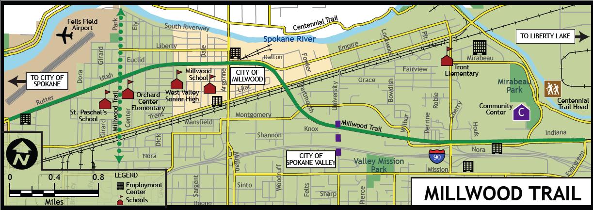
Background (How We Got To This Point) 1/11/2016 The Millwood Trail.was originally proposed in 2011 by the City of spokane Valley as a joint effort of Spokane Valley, City of Spokane and City of Millwood. The Trail was to be located on the former Great Northern Railway right of way which was acquired by Spokane County from Burlington Northern Railroad in the 1970's. When the joint project failed to proceed, Millwood decided to push forward with its one-mile section. Millwood obtained a lease from Spokane County to construct the trail within Millwood city limits which run from Vista Road east across Argonne Rd and past Millwood City Park to the Trent Avenue overpass. The County's right of way extends from near the west end of Felts Field to the Spokane Valley Mall. The following is the Project Description from City of Spokane Valley's original grant proposal: The project proposes to design a 6.5 mile non-motorized trail from Spokane Community College to the Spokane Valley Mall. The trail would be located on Spokane County owned railroad right-of-way that was once the route of the Great Northern Railway. It was turned over to BNSF, who then sold the right-of-way to Spokane County. The County has used the right-of-way for a sewer trunkline, but otherwise it has been mostly protected from encroachment by neighbors or construction of new crossings of the right-of-way. This makes it ideal for a trail route. The County has expressed interest in transferring the ownership of the right-of-way to the underlying jurisdictions. The project meets the eligibility requirements for two of the Transportation Enhancement categories: Provision of Facilities for Bicycles and Pedestrians and Preservation of Abandoned Railway Corridors. This grant application seeks funding to complete the design and environmental phases of the project. This would be a joint project between Spokane Valley, Spokane, and Millwood, with Spokane Valley acting as the lead. The grant application also included the following text describing the consistency of the proposed project with local transportation plans: The project significantly expands the choices for non-motorized travel between schools, recreation, commercial districts and residential areas. This is consistent with "Develop a balanced, integrated, multi-modal transportation system, which serves the existing and future needs of the area and provides convenient choice among modes for trips into and out of Spokane's metropolitan area, for work, school, shopping, personal business, and recreational purposes" (page 1 - section 1). The trail will provide a safer route for non-motorized travel, improve the quality of life for the neighborhood, and will provide a transportation alternative compatible with the neighborhood character. This is consistent with the policy that "Spokane's regional transportation system shall provide for the safe and efficient movement of people and goods throughout the Spokane region, while seeking to enhance the area's quality of life, efficiently using limited resources, and ensuring that transportation solutions are compatible with the rights of citizens to a peaceful and healthy enjoyment of life, home and property" (page 1 - section 1). The completion of this bicycle and pedestrian facility will encourage a larger modal split towards non-motorized, consistent with the policy to "Establish a bicycle and pedestrian program that will increase the mode-share of people walking and bicycling as a means of transportation in the Spokane Metropolitan Area over the next 20 years" (page 3 - section 1). Provision of a non-motorized route connecting between the residential neighborhood and adjacent commercial districts will be consistent with "encourage connections between residential areas and adjacent land uses by eliminating barriers that restrict bus, pedestrian, and bicycle circulation" (page 4 - section 1). To read more about how the Millwood Trail fits into the regional bicycle and pedestrian system you can go to the following links: City of Spokane Master Bike Plan https://my.spokanecity.org/projects/master-bike-plan/ City of Spokane Valley Bike and Pedestrian Master Plan http://www.spokanevalley.org/content/6836/6896/7078/7985.aspx SRTC Spokane Regional Bike Map https://srtc.maps.arcgis.com/home/webmap/viewer.html?webmap=a9c8901a015b4aea8c5e23a927a7fc41
|
|||