Timberworks - A flood resiliency and restoration plan for the cities of Aberdeen and Hoquiam
The Challenge
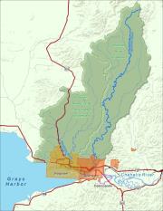
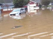
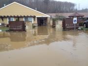
The Cities of Aberdeen and Hoquiam are located at the point where the Chehalis River meets the Grays Harbor Estuary. These twin cities historically flourished with economies based on logging and fishing. With the decline of those industries in recent decades, there has been significant loss of jobs and investment. The economic challenges facing these communities are exacerbated by chronic flood issues that cause financial and physical impacts. It is estimated that residents of the City of Aberdeen pay over $1 million per year in premiums to the National Flood Insurance Program. This represents a tremendous drain on household budgets in this low income area and has a chilling effect on property transactions in the FEMA flood zone.
The Opportunity
The two cities have built strong partnerships with Grays Harbor County and other cities in the region to build a more diversified and resilient economy, one where natural resources are used sustainably, downtowns and local businesses are vibrant, and where quality of life supports residents and attracts tourists. There is leadership at the municipal level, such as the partnership between the Cities of Aberdeen and Hoquiam to jointly update their Shoreline Management programs, and at the grassroots level, such as the Grays Harbor Vision 2020. In just three years, Vision 2020 has brought together over 30 local organizations and has initiated or completed 85 of 120 planned actions. Vision 2020 recently received the Governor’s Smart Communities Award.
Coordinated Coastal Resiliency Planning
The Cities of Aberdeen and Hoquiam are now developing a coordinated approach to reduce flooding, promote community development, and support salmon recovery efforts. The Cities are taking a two-pronged approach to develop a Coastal Resiliency Master Plan and design a protective levee system. The communities are impacted by a complex interaction of different types of flooding:
•Coastal flooding—driven by the combination of high tides, low pressure, and strong winds. This is the highest flood source and the primary factor in determining the FEMA flood zones.
•Riverine flooding—interactions of elevated flows in the Chehalis, Wishkah, and Hoquiam Rivers
•Small drainage flooding—occurs when urbanized, straightened streams overtop their banks during high rainfall events.
•Localized flooding—excessive rain events overwhelm the stormwater drainage system.
These local efforts align with the regional work of the Chehalis River Basin Flood Authority and will result in both a Master Plan and preliminary design and approval of a levee system.
The Master Plan will be developed through a community-based planning process. The intent of the Master Plan is to identify multiple benefit projects that can reduce flood risk, improve fish habitat, and increase public open space and recreation opportunities. Since coastal flooding has the broadest impacts, drives the FEMA flood insurance rate map, and has the fewest potential mitigation options in these developed communities, preliminary design of a levee system will proceed concurrently with the Master Plan. A preliminary levee design for downtown Aberdeen has already been prepared and received approval from FEMA. The levee system is relatively low and integrates into existing urban infrastructure, including roads and bridge crossings. This project will expand the levee to protect both Aberdeen and Hoquiam. These two efforts will mutually support each other.
- The Master Plan will educate the community about flood risks and solicit concerns and innovative solutions.
- The levee design process will provide technical information, including hydraulic and hydrologic analysis, to inform the Master Plan.
- The Master Plan will initiate opportunities for community input on the levee system that will continue through design, environmental review, and permitting.
|
||
|
||
|

Please Wait...