Summary of the project
Last Updated: November 16, 2015, 2015
Click HERE To Return To Main Flood Authority Website
Click HERE to Return To Grays Harbor County Flood Relief Projects
2012 Funding (Phase I) -- $50,000 (11/02/2012).
2013-15 Funding (Phase II) -- $450,000 (1/21/2014).
Description -- Phase I and Phase II are as follows:
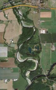
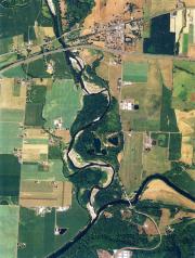
- Phase I -- The project design need is to identify alternatives for floodplain restoration. Satsop River Floodplain Restoration project consists of ~100 acres of floodplain habitat impaired by ~5,200 lineal feet of constructed dike and ~2,500 lineal feet of riprapped riverbank. Satsop Committee has identified the dike, riprap, three gravel extraction ponds, and excessive eroding banks as additional potential areas to focus restoration efforts to restore floodplain functions, re-establish access to off-channel habitat, and allow the Satsop River to access ~2/3 of its lower reach migration zone. This particular phase of the project will focus on evaluating possible benefits and impacts of removing all or a portion of the ~2,500-foot long rip-rap revetment on the east bank of the Satsop River approximately one mile downstream of State Highway 12 and will be completed by 06/29/2013.
- Phase II -- The goal of the Lower Satsop River Floodplain Restoration Project is to restore physical and natural fluvial processes to reduce soil and bank erosion, improve habitat complexity, and improve floodplain connectivity. The project will build on the recently completed Phase I Satsop River Riprap Removal Restoration Project which developed background information and identified a range of conceptual project alternatives (25+ alternatives).
The benefits, impacts, and potential future evolution of the most promising alternatives from that Phase I final report will be evaluated using the SRH-2D hydraulic model developed for the previous project and by conducting in-depth hydrologic and geomorphic analyses. Together with project stakeholders a preferred alternative will be selected based on the results of the modeling and analysis. A basis of design report, 60% design plans, and permit documents will be prepared for the selected alternative.
Flood Hazard Reduction Benefits -- The intended flood benefit of the proposed project is to reduce erosion, save farm soils and create better fish and wildlife habitat (Phase I). The intended benefit is to restore natural fluvial processes and floodplain connectivity to reduce soil and bank erosion, preserve agricultural soils, and improve fish and wildlife habitat (Phase II).
Project Status -- On-track, On-schedule.
Project Schedule:
Phase II:
- By 06/30/2015 -- Complete design and permit documents.
- DONE -- Stakeholder kick-off meeting scheduled for March 25, 2014 (click here for invite).
- DONE -- By 01/01/2015 -- Work with WDFW Habitat engineers, regional staff, local landowners, and key stakeholder organizations (e.g., local Conservation District) to refine and analyze alternatives.
- DONE -- By 01/01/2014 -- Contract with an engineering firm with expertise in hydraulics/fluvial processes and knowledge of the lower Satsop River project reach.
- DONE -- 10/17/2013 -- Flood Authority approves moving a WDFW Phase II project forward with remaining 2012 Jobs Now Act $. Click here.
Phase I:
- DONE -- 7/08/2013 -- Grays Harbor County Commission action. Click here.
- DONE -- 6/28/2013 -- Final report issued. Click here.
- DONE -- 6/22/2013 -- Presentation of results.
- DONE -- 4/06/2013 -- Alternatives development meeting.
- DONE -- 3/16/2013 -- Presentation of baseline information.
- DONE -- 1/10/2013 -- Stakeholder kick-off meeting.
- DONE -- 12/22/2012 -- Notice to Proceed for Consultant hired by Grays Harbor County.
- DONE -- Nov./Dec. 2012 -- Interagency funding agreement between Grays Harbor County and OFM approved.
- DONE -- 10/02/2012 -- Funding approved for Grays Harbor County by CRBFA and Chehalis Tribe (click here).
Pictures
|
||
|

Please Wait...