Project Financials -- See separate project financials website here.
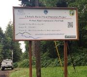
Description -- Purpose of the project is to study the frequency, duration and extent of flooding on the Wishkah Road between M.P. 2.2 and M.P. 7.6 and identify cost effective flood hazard reduction alternatives for the following:
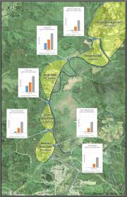
Study Area #1 -- Baretich Flats (M.P. 2.2).
Study Area #2 -- Ellison Dip (M.P. 3.8).
Study Area #3 -- Long Swamp (M.P. 5.0).
Study Area #4 -- Monarch Creek (M.P. 5.8).
Study Area #5 -- Vienna Tracts (M.P. 7.6).
The project will:
Review and evaluate previous studies, reports, and information.
Determine flood elevation, depth, duration and frequency for various low points within the comprehensive study area.
Identify and evaluate alternatives that eliminate or reduce Wishkah Road flood closures within the comprehensive study area.
Prepare preliminary plan, design and construction cost estimates for each alternative proposal within the comprehensive study area.
Determine feasibility and adverse impacts/effects for each alternative proposal within the comprehensive study area.
Provide hydraulic modeling for each feasible alternative proposal within the comprehensive study area.
Provide benefit/cost analysis for each feasible alternative proposal within the comprehensive study area.
Identify permits and regulatory requirements for each feasible alternative proposal within the comprehensive study area.
Identify property and easements needed for each feasible alternative proposal within the comprehensive study area.
Recommend a comprehensive package of feasible alternatives for final design covering the comprehensive study area.
Provide scope, schedule, and sequencing for final design and permits for recommended projects.
Implement a community awareness and engagement strategy that will include community meetings at critical junctures of the project, publically accessible website containing critical information documents, advertisement of key decisions and the schedule for such, etc.
Flood Hazard Reduction Benefits -- Project will benefit residents of Grays Harbor County, particularly those who reside or travel north of Aberdeen on the Wishkah Road, by ensuring (ultimately) the passability of the Wishkah Road, particularly in times of flood emergency.
Project Status -- On-Track, Underway.
Schedule/Milestones -- Current schedule is as follows: