Last Updated: December 4, 2024
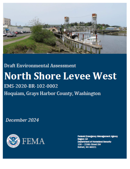
Project Overview
The Aberdeen-Hoquiam Flood Protection Project is comprised of two critical levees, the North Shore Levee and the North Shore Levee – West Segment, which are needed to protect the cities of Aberdeen & Hoquiam.
Coordinated Coastal Resiliency Planning
The cities of Aberdeen and Hoquiam are working together on a coordinated approach to reduce flooding, promote community development, and support salmon recovery efforts. The cities are following a two-pronged approach to implement the Coastal Resiliency Master Plan and design/construct a protective levee system. The communities are impacted by a complex interaction of different types of flooding:
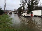
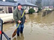
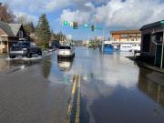
- Coastal flooding—driven by the combination of high tides, low pressure, and strong winds. This is the highest flood source and the primary factor in determining the FEMA flood zones.
- Riverine flooding—interactions of elevated flows in the Chehalis, Wishkah, and Hoquiam Rivers
- Small drainage flooding—occurs when urbanized, straightened streams overtop their banks during high rainfall events.
- Localized flooding—excessive rain events overwhelm the stormwater drainage system.
These local efforts align with the regional work of the Chehalis River Basin Flood Authority, resulting in both a Master Plan and preliminary design and approval of a levee system.
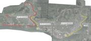
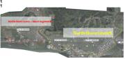
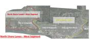
North Shore Levee - West Segment
The North Shore Levee—West Segment, estimated to cost $40 million to construct, will build a 4.7-mile levee (earthen, concrete, and sheet pile) bordering the west side of Hoquiam. This levee will protect local residents and build resiliency in the face of future flood events, as well as retain existing businesses, jobs, and residents that have been on the decline in this community. Questions on the North Shore Levee - West Segment can be submitted to Brian Shay, City Administrator, City of Hoquiam BShay@cityofhoquiam.com
Activities: North Shore Levee - West Segment
- December 16, 2024: FEMA, Washington EMD (WSEMD), and the City of Hoquiam are hosting a Meeting and Open House on the Draft EA for the NSL-W at the Hoquiam City Hall from 5:30 p.m. to 7:30 p.m. A formal presentation is planned from 5:30 p.m. to 6:15 p.m with an Open House running from 6:15 p.m. to 7:30 p.m. The Draft EA is available on the Library Tab of this webpage for review. The Comment period runs from December 9, 2024, to January 22, 2025. A factsheet can be found in the Library Tab.
 The Draft Environmental Assessment (DEA) can be found in the Library Tab
- September 4, 2024: The City of Hoquiam, as the lead agency for SEPA has issued a Mitigated Determination of Nonsignificance - Comments are due by Sept 25, 2024.
- May 2024: Utility Insert is sent to residents describing the current stage of design - the project is currently in the Final Design Stage.
Current Schedule:
- Design (2021 - 2025) Conducted community outreach and collected feedback; are currently working to secure regulatory approval (e.g. Environmental Assessment), and developing increasingly detailed designs that reflect community and stakeholder feedback. Other elements being worked on include internal drainage, such as the 10th Street Stormwater Pump Station currently under construction.
- Construction (As soon as Q4 2025 and lasting 2 years) Dependent upon the timing of the completion of the FEMA Environmental Review and receiving permits.
We will keep the community informed on the construction updates, schedules, and expected impacts as the information becomes available. FEMA, WSEMD, a Meeting and Open House on the project starting with check-in starting at 5:15 p.m. The formal presentation is scheduled from 5:30 p.m. to 6:15 p.m. Please refer back to this project site for more information, which is anticipated to be posted in early December.
See Library Tab for Utility Insert with graphic of current timeline.
- May 16, 2023- Governor Inslee signs the WA State Capital Budget, inclusive of $35.5 million over the course of 2023-2025 and 2025-2027 fiscal biennia.
- March 23, 2023- Cities of Aberdeen and Hoquiam issue Press Release on Senate Capital Budget's inclusion of $18.5 million in '23-'25 Budget
The Press Release can be found under the Library tab.
- April 14, 2023- Application for Congressional Designated Spending submitted to FEMA to secure funds for Aberdeen Waste Water Treatment Plant flood protection by September 2023.
- December 2022- Federal Spending Package includes $5 million for Aberdeen-Hoquiam Flood Project.
The cities worked with FEMA in Spring 2023 to submit a funding application in order to obligate these funds by September 2023.
- August 2022 - FEMA, State Emergency Management and Local Leaders Announce Historic Investments in Climate and Disaster Resilience
FEMA Region 10 Administrator Wille G. Nunn joined Washington Emergency Management Division Director Robert Ezelle and local leaders in Aberdeen, WA, to announce Washington projects selected as part of President Biden's historic $1.16 billion climate and disaster resilience investment and the availability of an additional $3.095 billion in funding opportunities for communities in Fiscal Year 2022. The event took place near the location of the planned North Shore Levee project which was selected to receive $50 million and will provide critical flood protection for residents and businesses across Aberdeen and Hoquiam.
- May 2022 - Date Set for FEMA Scoping Open House - June 22, 2022, 4 pm - 6 pm at Hoquiam City Hall - See Events page for more details of the Open House.
- March 12, 2022 - Congressmen Kilmer locks down $9.95 million in federal funding for Aberdeen, Hoquiam Flood Protection Project
- June 2021 - $4 Million Grant from the Office of Chehalis Basin Announced
The $4 million will be used to complete final design and Right of Way Acquistion to achieve shovel ready construction status in 2023. Final Design is underway and may result in some changes to the current alignment.
- May 2021 - CLOMR Issued by FEMA for North Shore Levee - West Segment
The Federal Emergency Management Agency (FEMA) has issued a Conditional Letter of Map Revision (CLOMR) for the proposed North Shore Levee - West Segment. FEMA's issuance of a CLOMR is confirmation that, once the levee is built and certified, FEMA will redraw local Flood Insurance Rate Maps (FIRMs) to reflect levee protection. Within the limits of levee protection, areas that are currently mapped as Special Flood Hazard Area (SFHA) due to coastal flooding will be removed from the 100-year coastal floodplain and remapped as Zone X. This is a major milestone for the North Shore Levee project as it ensures that the project, once constructed, will result in the intended mapping changes.
The City of Hoquiam is working to design and build the North Shore Levee - West Segment to provide flood protection for low-lying parts of Hoquiam, west of the Hoquiam River, north of the Chehalis River, and Grays Harbor Estuary. This segment is a continuation of the North Shore Levee project directly east of the Hoquiam River in East Hoquiam and West Aberdeen. That project received a CLOMA in 2017.
The purpose of the levee is to protect the downtown business district, critical infrastructure, and residences in the City of Hoquiam from damaging floods and to reduce the financial burden of flood insurance and floodplain development regulations. The protected areas will be removed from the Special Flood Hazard Area Zone AE and placed in a Zone X. The City of Hoquiam has suffered from long-term economic depression and high unemployment. The removal of mandatory flood insurance for a majority of properties located within the floodplain will provide a desperately needed boost to the local economy.
The next step in this process is to finalize the design of the Levee and go through the ROW acquisition and permitting processes. Funding to continue design and permitting has been allocated by the Chehalis River Basin Flood Authority for the 2021-2023 biennium. The Flood Protection Project also received a Congressional Designated Spending Appropriation in FY22 of $9.950 million for this pre-construction work. The West Segment is anticipated to be at 90% design near the end of 2023. Construction is anticipated to be bid-ready by the end of 2024. Construction is scheduled to begin in 2025 and be completed in late 2026, pending environmental review, permitting, and ROW acquisition.
|
||
|
||
|
||
|
||
|
||
|
||
|
||
|

Please Wait...